
Page 81 - Haryana Water Resources Atlas 2025
P. 81
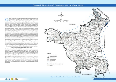
Ground Water Level  Contours (As on June 2023)


                                                                                                                              N

                                                                                                                        W          E


                                                                                                                              S
                   round Water level contours represent lines connecting points on the
                   ground surface that share the same elevation of the water level.                                          Scale
            GThese contours play a vital role in comprehending the movement                                                                Kms
                                                                                                                0  12.5 25   50    75    100
            and shape of Ground Water within an aquifer. Typically, Ground Water level
            contours are established by measuring the water level depth at various
            locations  using  monitoring  wells  or  other  Ground  Water  measurement
            tools. This data is then utilized to generate a contour map illustrating the
            elevations of the water level, with lines connecting points of equal elevation.
            Ground  Water  level  contour  maps  offer  significant  insights  for  diverse
            purposes. They aid in understanding the movement of contaminants in
            Ground Water, identifying suitable areas for well installation, and assessing
            the potential for Ground Water recharge. It is critical to understand that
            Ground Water level contours are dynamic and subject to change over time as
            a result of both natural and man-made factors, such as shifting precipitation
            patterns, Ground Water extraction, or modifications to land use. Regular
            monitoring and updating of Ground Water level contour maps are necessary
            to ensure their accuracy and usefulness in decision-making processes.
            Ground Water level contours serve as a valuable tool for comprehending the
            dynamics of Ground Water systems and formulating effective strategies for
            the sustainable management of Ground Water resources. The depth to the
            Ground Water level can be estimated using the equation below, which can
            further be employed to create interpolated surfaces for contour generation.

             Elevation of Water Level (EWL) = Elevation of Ground Surface
                        (RL) - Depth to Ground Water Level (WL)
            The  Elevation  of  Water  Level  (EWL)  was  utilized  to  create  contours  at
            intervals of 5-10 meters, as depicted in Figure 43. These contours were
            further  employed  to  generate  the  Ground  Water  flow  pattern.  In  the
            northern part of the state, the predominant flow direction was observed to
            be towards the south and southwest. However, the flow originating from the
            Aravalli range exhibited a northeasterly direction.
            Ground Water level contours find applications in various aspects of Ground
            Water management. For instance, they can guide decisions regarding where
            to implement recharge measures to benefit other areas. It is worth noting
            that  Ground  Water  movements  play  a  role  in  causing  waterlogging,
            particularly in central Haryana, as most of the Ground Water flows towards
            this region.


                                                                                                         Figure 43. Ground Water Level  Contours (As on June 2023)
                                                                                                                                                                                              Data Source-GWC, Haryana
                                                                                                                                                                                                     Haryana Water Resources  Atlas     63|