
Page 82 - Haryana Water Resources Atlas 2025
P. 82
Ground Water Flow (As on June 2023)
N
W E
round Water flow refers to the movement of water through the
underground spaces of soil, rocks, and geological formations. It is a vital S
Gpart of the hydrological cycle and plays a crucial role in maintaining Scale
surface water resources, supporting ecosystems, and providing drinking water Kms
to communities. The movement of Ground Water is influenced by various 0 12.5 25 50 75 100
factors, including the permeability and porosity of soil and rocks, land
topography, precipitation rates, and Ground Water extraction rates. Ground
Water can flow vertically from recharge areas-where water enters the Ground
Water system-to discharge areas-where it emerges at the surface or joins
streams, lakes, or seas. It can also flow horizontally, following the slope of land or
subsurface strata. To study Ground Water flow, methods such as well drilling,
tracer tests, and computer models are employed to simulate water movement in
the subsurface. This information is essential for understanding Ground Water
availability and quality, managing its use and recharge, and safeguarding
ecosystems and communities dependent on Ground Water.
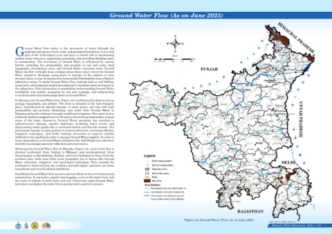
In Haryana, the Ground Water flow (Figure 44) is influenced by factors such as
geology, topography, and climate. The state is situated in the Indo-Gangetic
plain, characterized by alluvial deposits of sand, gravel, and clay with high
permeability and porosity, facilitating easy water flow. Ground Water in
Haryana primarily recharges through rainfall and irrigation. The water level is
relatively shallow, ranging from 3 to 20 meters below the ground surface in most
areas of the state. Excessive Ground Water pumping has resulted in
infrastructure damage, aquifer depletion, declining water levels, and
deteriorating water quality due to increased salinity and fluoride content. The
government has put in place policies to control extraction, encourage effective
irrigation techniques, and build recharge structures to improve rainfall
infiltration into aquifers in order to manage Ground Water supplies. In order to
lessen dependency on Ground Water, initiatives like Atal Bhujal have also been
started to encourage rainwater collection and conservation.
Observing the Ground Water flow in Haryana (Figure 44), most of the flow is
directed southward (from Rohtak to Bhiwani) and southwestward (from
Yamunanagar to Kurukshetra, Kaithal, and from Fatehabad to Sirsa) from the
northern part, while some flows occur irregularly due to factors like Ground
Water extraction, irrigation, and canal-based recharging. Flow towards the
northeast is observed from the southern Aravalli region, and there are flows
towards the east from Faridabad and Palwal.
Insufficient Ground Water flow can have adverse effects on the environment and
communities. It can lead to aquifer waterlogging, a rise in the water level, and
the onset of salinity in both water and soil. Conversely, rapid Ground Water
movement can deplete the water level, causing water scarcity in an area.
Figure 44. Ground Water Flow (As on June 2023)
Data Source-GWC, Haryana
Haryana Water Resources Atlas 64|