
Page 80 - Haryana Water Resources Atlas 2025
P. 80
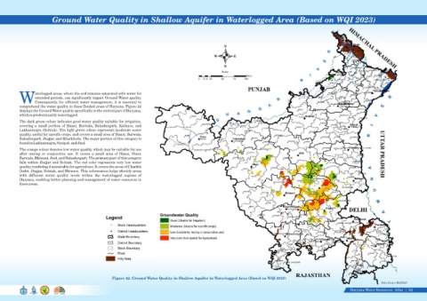
Ground Water Quality in Shallow Aquifer in Waterlogged Area (Based on WQI 2023)


                                                                                                                              N

                                                                                                                        W          E


                                                                                                                              S
                                                                                                                             Scale
                                                                                                                                           Kms
                                                                                                                0  12.5 25   50    75    100


                    aterlogged areas, where the soil remains saturated with water for
                    extended periods, can significantly impact Ground Water quality.
            WConsequently, for efficient water management, it is essential to
            comprehend the water quality in these flooded areas of Haryana. Figure 42
            displays the Ground Water quality specifically in the central part of Haryana,
            which is predominantly waterlogged.
            The dark green colour indicates good water quality suitable for irrigation,
            covering  a  small  portion  of  Hansi,  Barwala,  Bahadurgarh,  Kathura,  and
            Lakhanmajra (Rohtak). The light green colour represents moderate water
            quality, useful for specific crops, and covers a small area of Hansi, Barwala,
            Bahadurgarh, Jhajjar, and Kharkhoda. The major portion of this category is
            found in Lakhanmajra, Sonipat, and Jind.

            The orange colour denotes low water quality, which may be suitable for use
            after  mixing  or  conjunctive  use.  It  covers  a  small  area  of  Hansi,  Hisar,
            Barwala, Bhiwani, Jind, and Bahadurgarh. The primary part of this category
            falls within Jhajjar and Rohtak. The red color represents very low water
            quality, rendering it unsuitable for agriculture. It covers the areas of Charkhi
            Dadri, Jhajjar, Rohtak, and Bhiwani. This information helps identify areas
            with  different  water  quality  levels  within  the  waterlogged  regions  of
            Haryana, enabling better planning and management of water resources in
            these areas.


                                                                Figure 42. Ground Water Quality in Shallow Aquifer in Waterlogged Area (Based on WQI 2023)
                                                                                                                                                                                                                      Data Source-HARSAC

                                                                                                                                                                                                     Haryana Water Resources  Atlas     62|