
Page 27 - Haryana Water Resources Atlas 2025
P. 27
Slope
N
W E
S
Scale
Kms
0 12.5 25 50 75 100
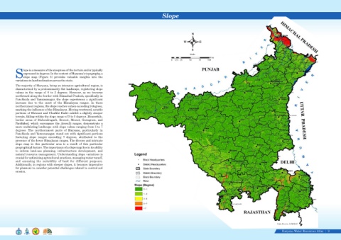
lope is a measure of the steepness of the terrain and is typically
expressed in degrees. In the context of Haryana's topography, a
Sslope map (Figure 5) provides valuable insights into the
variations in land inclination across the state.
The majority of Haryana, being an intensive agricultural region, is
characterized by a predominantly flat landscape, registering slope
values in the range of 0 to 3 degrees. However, as we traverse
northward along the border with Himachal Pradesh, specifically in
Panchkula and Yamunanagar, the slope experiences a significant
increase due to the onset of the Himalayan ranges. In these
northernmost regions, the slope reaches values exceeding 8 degrees,
marking the influence of the Himalayas. Moving westward, notable
portions of Bhiwani and Charkhi Dadri exhibit a slightly steeper
terrain, falling within the slope range of 3 to 5 degrees. Meanwhile,
border areas of Mahendragarh, Rewari, Mewat, Gurugram, and
Faridabad, which encompass the Aravalli ranges, demonstrate a
more undulating landscape with slope values ranging from 5 to 7
degrees. The northernmost parts of Haryana, particularly in
Panchkula and Yamunanagar, stand out with significant portions
featuring slope ranges exceeding 7 degrees, attributed to the
presence of the lower Himalayan ranges. The diverse and intricate
slope map in this particular area is a result of this particular
geographical feature. The importance of a slope map lies in its ability
to inform land-use planning, infrastructure development, and
natural resource management. Understanding slope variations is
crucial for optimizing agricultural practices, managing water runoff,
and assessing the suitability of land for different purposes.
Additionally, in regions with steeper slopes, it becomes imperative
for planners to consider potential challenges related to control soil
erosion.
Figure 5. Slope Data Source-HARSAC
Haryana Water Resources Atlas 9|