
Page 24 - Haryana Water Resources Atlas 2025
P. 24
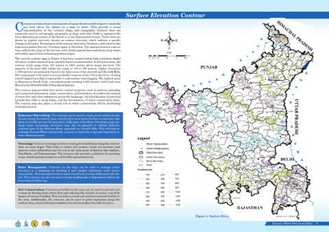
Surface Elevation Contour


                  ontours are lines that connect points of equal elevation with respect to mean the
                  sea  level  above  the  datum  on  a  map  or  chart.  They  provide  a  visual
            Crepresentation  of  the  terrain's  shape  and  topography.  Contour  lines  are
            commonly used in cartography, geography, geology, and other fields to represent the                            N
            three-dimensional surface of the Earth in a two-dimensional format. These lines are
            drawn  at  regular  intervals,  known  as  contour  intervals,  which  indicate  a  specific             W          E
            change in elevation. For instance, if the contour interval is 10 meters, each contour line
            represents points that are 10 meters apart in elevation. The spacing between contour
                                                                                                                           S
            lines reflects the slope of the terrain, with closely spaced lines indicating steep slopes
            and widely spaced lines indicating gradual slopes.                                                            Scale
                                                                                                                                       Kms
            The current contour map in Figure 2 has been created using high-resolution digital              0  12.5 25   50     75    100
            elevation models obtained from satellite-based measurements. In Haryana state, the
            contour  levels  range  from  130  meters  to  1467  meters  above  mean  sea  level.  The
            majority of the land falls within the range of 130 to 300 meters. Higher elevations
            (>300 meters) are primarily found in the hilly areas of the Aravalli and Shivalik Hills.
            The central part of the state is surrounded by contours at the 170-meter level, creating
            a bowl-shaped area that is susceptible to sub-surface waterlogging. The highest point
            in Haryana is Karoh Peak, a mountain peak reaching 1,467 meters (4,813 feet) near
            Morni in the Shiwalik Hills of Panchkula district.
            The contour map provided here serves various purposes, such as land-use planning,
            environmental assessment, water conservation, and recreation. It enables the analysis
            of water flow and other substances across the landscape, the identification of potential
            hazards like cliffs or steep slopes, and the development of water conservation plans.
            The contour map also plays a crucial role in water conservation efforts, facilitating
            strategies such as:


              Rainwater Harvesting: The contours can be used to create small earthen bunds
              (berms) along the contour lines, which help to slow down the flow of rainwater and
              allow it to infiltrate into the ground in a hilly part of the State. Simultaneously, the
              small  water  harvesting  structures  may  also  be  planned  in  rainfall  deficient
              southern part of the Haryana State, especially in Aravalli Hills. This will help to
              recharge Ground Water and provide a source of water for crops and vegetation in
              water-deficient areas.


              Terracing: Contour terracing involves creating level platforms along the contour
              lines on steep slopes. This helps to reduce soil erosion, retain soil moisture and
              improve water infiltration into the soil in the hilly areas of districts like Ambala,
              Panchkula, and Yamunanagar. The terraces also provide a platform for growing
              crops, which can help to improve soil fertility and productivity.


              Water  Management:  Contours  on  the  map  can  be  used  to  manage  water
              resources  in  a  landscape  by  dividing  it  into  smaller  catchment  areas  (micro
              watersheds). This can help to reduce water runoff and increase infiltration into the
              soil. The contours can also be used to create small ponds or depressions which can
              store water for later use.


              Soil Conservation: Contours provided on the map can be used to prevent soil
              erosion by slowing down water flow and reducing the velocity of surface runoff by
              means of contour building. This can help to retain soil moisture and soil fertility in
              the  area.  Additionally,  the  contours  can  be  used  to  grow  vegetation  along  the
              contour lines, which will help to stabilize the soil and reduce the risk of erosion.


                                                                                                                                               Figure 2. Surface Elevation Contour                       Data Source-HARSAC

                                                                                                                                                                                                      Haryana Water Resources Atlas     6|