
Page 25 - Haryana Water Resources Atlas 2025
P. 25
Elevation
N
W E
S
levation refers to the height above a specified Scale
reference point, usually sea level, and is a crucial Kms
Easpect of understanding the topography of a region. 0 12.5 25 50 75 100
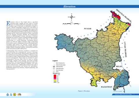
The elevation map of Haryana, as illustrated in Figure 3,
unveils a diverse topography ranging from 130 meters to
1467 meters above mean sea level. Two distinct regions with
elevations below 200 meters are identified: the southeastern
districts of Faridabad and Palwal, influenced by the Yamuna
drainage and the westernmost district of Sirsa, associated
with the Ghaggar drainage. Notably, the southwestern
districts of Mahendragarh, Rewari, and parts of Bhiwani
alongside the northern regions of Ambala and Yamunanagar
exhibit elevations ranging from 265 to 444 meters,
contributing to a varied landscape. Panchkula district
stands out with the highest elevation range, progressing
from south to north, culminating in the northernmost parts
exceeding 1200 meters. In contrast, central Haryana
comprising districts such as Hisar, Jind, Sonipat, Panipat,
Jhajjar, Rohtak, Fatehabad, Kaithal, and Karnal maintains
an elevation between 200 to 265 meters.
Understanding these elevation variations is essential for
comprehending the geographical nuances, drainage
patterns, and overall terrain characteristics depicted in the
provided elevation map of Haryana Figure 3. Elevation maps
are integral to water-related and agriculture-related natural
resource management. These maps are essential for water
management because they may be used to define
watersheds, evaluate flood hazards, and locate possible
Ground Water. This information helps planners make well-
informed decisions when designing irrigation and water
delivery infrastructure. Additionally, elevation data aids in
analyzing microclimates and terrain for agriculture,
facilitating optimal crop selection, irrigation planning, and
risk assessment.
Figure 3. Elevation
Data Source-HARSAC
Haryana Water Resources Atlas 7|