
Page 30 - Haryana Water Resources Atlas 2025
P. 30
Land Use and Land Cover (2022-2023)
N
W E
S
Scale
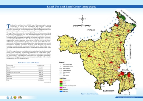
he Land Use and Land Cover (LULC) map of Haryana, compiled using a
Kms
combination of satellite and ground-based data, provides a detailed 0 12.5 25 50 75 100
Tportrayal of the state's dynamic and evolving landscape. This cartography
intricately delineates the various applications of land across Haryana capturing
the intricate interplay between natural features and human activities.
The map (Figure 8) showcases the dominant LULC classes in Haryana, quantifying
the extent of each category in acres. Vast agricultural expanses cover a substantial
portion, totalling 9,207,843.60 acres, emphasizing the state's agricultural prowess.
Urban areas and infrastructure development are reflected in the Built-Up category,
accounting for 944,658.45 acres. The Forest category illustrates Haryana's
commitment to environmental conservation, covering 322,247.94 acres.
Additionally, the grassland and grazing land category spans 90,861.92 acres,
contributing to the state's pastoral landscape. Other land uses, comprising various
miscellaneous categories, encompass 43,028.31 acres. Wasteland, an area in
transition or underutilized, constitutes 157,009.20 acres. Water bodies cover
159,356.85 acres reflecting the importance of aquatic resources in the region (Table
9)
The LULC map reflects not only the distribution of land uses but also the nuanced
details of land cover types, encompassing information on forests, water bodies,
industrial zones, and residential areas. This nuanced representation is invaluable
for urban planning, environmental conservation, and sustainable development
initiatives, providing policymakers, researchers, and stakeholders with a reliable
foundation for informed decision-making.
Table 9. Area under LULC classes
LULC Class Area in Acres
Agriculture Land 9207843.60
Built Up 944658.45
Forest 322247.94
Grassland and Grazing Land 90861.92
Others 43028.31
Wasteland 157009.20
Water Body 159356.85
TGA 10925006.26
Source: HARSAC
Figure 8. Land Use and Land Cover (2022-2023)
Data Source-HARSAC
Haryana Water Resources Atlas 12|