
Page 32 - Haryana Water Resources Atlas 2025
P. 32
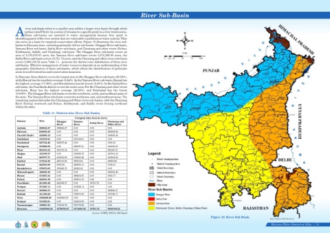
River Sub-Basin


                    river sub-basin refers to a smaller area within a larger river basin through which
                   surface runoff flows via a series of streams to a specific point in a river watercourse.
                                                                                                                                      N
            AThese  sub-basins  are  essential  to  water  management  because  they  assist  in
            identifying parts of the river system that are vulnerable to pollution or water scarcity. They
                                                                                                                                W          E
            also serve as a basis for targeted conservation efforts. Figure 10 illustrates the river sub-
            basins in Haryana state, consisting primarily of four sub-basins: Ghaggar River sub-basin,
            Yamuna River sub-basin, Satluj River sub-basin, and Chautang and other rivers (Dohan,                                     S
            Krishnavati, Sahibi, and Chautang) sub-basin. The Ghaggar River sub-basin covers an                                     Scale
            area of 3,570,878.07 acres, the Yamuna River sub-basin covers 3,374,295.95 acres, the                                                 Kms
            Satluj River sub-basin covers 19,701.72 acres, and the Chautang and other rivers sub-basin                 0  12.5 25   50     75    100
            covers 3,960,130.52 acres Table 11.  presents the district-wise distribution of these river
            sub-basins. Effective management of water resources depends on an understanding of the
            geographic distribution of these sub-basins, which allows the identification of particular
            areas in need of attention and conservation measures.
            In Haryana, Sirsa district covers the largest area in the Ghaggar River sub-basin (29.59%),
            while Karnal has the smallest coverage (0.24%). In the Yamuna River sub-basin, Karnal has
            the highest coverage (17.98%), and Kurukshetra has the lowest (0.83%). In the Satluj River
            sub-basin, the Panchkula district covers the entire area. For the Chautang and other rivers
            sub-basin,  Hisar  has  the  highest  coverage  (22.25%),  and  Fatehabad  has  the  lowest
            (0.039%). The Ghaggar River sub-basin covers the northwest, north, and northeast parts of
            the state. The Yamuna River sub-basin covers the northeast, east, and southeast areas. The
            remaining regions fall under the Chautang and Other rivers sub-basins, with the Chautang
            River  flowing  westward  and  Dohan,  Krishnavati,  and  Sahibi  rivers  flowing  northeast
            within the state.
                                Table 11. District-wise River Sub Basins

                                                       Category wise Area in Acres
             District        TGA          Ghaggar     Yamuna                   Chautang and
                                          River       River       Satluj River   Other River
             Ambala          388943.27    388943.27   0.00        0.00         0.00
             Bhiwani         848064.36    0.00        0.00        0.00         848064.36
             Charkhi Dadri   332603.33    0.00        0.00        0.00         332603.33
             Faridabad       183104.81    0.00        183104.81   0.00         0.00
             Fatehabad       627152.49    625587.44   0.00        0.00         1565.05
             Gurugram        310858.09    0.00        206507.21   0.00         104350.88
             Hisar           984219.22    102722.14   0.00        0.00         881497.07
             Jhajjar         453190.57    0.00        125689.47   0.00         327501.10
             Jind            667677.71    233252.59   130821.48   0.00         303603.65
             Kaithal         572542.29    486118.66   36553.64    0.00         49869.98
             Karnal          622704.60    9032.83     606925.16   0.00         6746.61
             Kurukshetra     378070.65    350049.73   28020.92    0.00         0.00
             Mahendragarh    469252.40    0.00        0.00        0.00         469252.40
             Mewat           372387.24    0.00        368824.47   0.00         3562.77
             Palwal          335815.70    0.00        335815.70   0.00         0.00
             Panchkula       221900.29    202198.57   0.00        19701.72     0.00
             Panipat         313329.14    0.00        313329.14   0.00         0.00
             Rewari          393885.37    0.00        0.00        0.00         393885.37
             Rohtak          431198.23    0.00        193572.52   0.00         237625.71
             Sirsa           1056868.09   1056868.09   0.00       0.00         0.00
             Sonipat         524356.81    0.00        524354.56   0.00         2.25
             Yamunanagar     436881.64    116104.76   320776.88   0.00         0.00
             Haryana         10925006.26   3570878.07   3374295.95   19701.72   3960130.52
                                                                    Source: CGWB, INDIA/ GIS Based
                                                                                                                                                         Figure 10. River Sub Basin
                                                                                                                                                                                                     Data Source-FSI, Haryana
                                                                                                                                                                                                     Haryana Water Resources Atlas     14|