
Page 28 - Haryana Water Resources Atlas 2025
P. 28
Soil Types
oil is a comprehensive term that refers to the loose layer of earth covering the Earth's N
surface. It consists of disintegrated rock, humus, and both inorganic and organic
Smaterials. The process of rock transformation into soil typically takes an average of 500 W E
years or more. Soil formation occurs when rocks are broken down into their constituent parts.
Various forces, such as wind, water, and chemical reactions, contribute to the breakdown of S
rocks and the formation of soil.
Scale
Understanding the information and distribution of soil types in a particular geographical Kms
region is crucial for agricultural planning and recharge structure planning. By assessing 0 12.5 25 50 75 100
factors such as infiltration rate, water-holding capacity, runoff, and erosion potential of
different soil types, water conservation efforts can be optimized to effectively capture and
store water for plant growth, Ground Water recharge, and other uses.
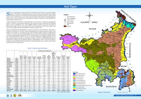
Figure 6 illustrates the distribution of various soil types across Haryana. The state is
comprised of a total of 11 soil types, with their geographical coverage presented in Table 7. The
largest area (30.05%) is covered by the soil of the old alluvial plain, while the smallest area
(1.68%) is covered by the soil of Siwalik Hills. The soil of the active floodplain has the highest
coverage in Yamunanagar. Similarly, the soil of Aeolian Plain is predominant in Bhiwani, the
soil of Aravalli Hills in Palwal, the soil of Aravalli Piedmont in Mahendragarh, soil of
Fluvioaeolian Plain in Rewari, soil of Old Alluvial Plain in Jind, soil of Old Alluvial Plain with
Sand Dunes in Hisar, soil of Piedmont Plain in Yamunanagar, soil of recent flood plain in
Panipat, and soil of Siwalik Hills in Panchkula. Detailed ground-water condition at the village
level is presented in Annexure II.
Table 7. District-wise Soil Types
Soil Types Area in '000 Acres
Old
Alluvial
Plain
Active Aeo- Fluvio Old With Recent
Flood fluvial Aeolian Aravalli Aravalli aeolian Alluvial Sand Piedmont Flood Siwalik
District TGA Plain Plain Plain Hills Piedmont Plain Plain Dunes Plain Plain Hills
Ambala 388.94 74.81 0.00 0.00 0.00 0.00 0.00 92.10 0.00 51.55 154.58 15.90
Bhiwani 848.06 0.00 0.00 285.80 2.68 0.00 80.08 0.00 479.51 0.00 0.00 0.00
Charkhi Dadri 332.60 0.00 0.00 12.05 2.33 27.08 255.32 0.00 35.82 0.00 0.00 0.00
Faridabad 183.10 14.95 0.00 0.00 9.44 54.85 0.00 62.38 11.09 0.00 30.39 0.00
Fatehabad 627.15 13.60 155.57 0.00 0.00 0.00 0.00 5.14 305.02 0.00 147.83 0.00
Gurugram 310.86 0.00 0.00 0.00 16.91 108.07 55.85 20.24 62.77 0.00 47.04 0.00
Hisar 984.22 0.00 19.79 7.82 0.00 0.00 0.00 216.86 739.74 0.00 0.00 0.00
Jhajjar 453.19 0.00 0.00 0.00 1.41 0.00 0.00 300.95 94.95 0.00 55.87 0.00
Jind 667.68 0.00 0.00 0.00 0.00 0.00 0.00 530.95 136.72 0.00 0.00 0.00
Kaithal 572.54 12.86 0.00 0.00 0.00 0.00 0.00 518.04 0.00 0.00 41.65 0.00
Karnal 622.70 60.29 0.00 0.00 0.00 0.00 0.00 333.30 6.63 0.00 222.48 0.00
Kurukshetra 378.07 0.00 0.00 0.00 0.00 0.00 0.00 378.07 0.00 0.00 0.00 0.00
Mahendragarh 469.25 0.00 0.00 0.00 19.92 248.76 197.48 0.00 3.10 0.00 0.00 0.00
Mewat 372.39 6.75 0.00 0.00 18.69 237.27 0.00 109.68 0.00 0.00 0.00 0.00
Palwal 335.82 42.36 0.00 0.00 116.81 0.00 0.00 0.00 0.00 0.00 176.64 0.00
Panchkula 221.90 4.06 0.00 0.00 0.00 0.00 0.00 22.72 0.00 17.06 39.22 138.84
Panipat 313.33 0.00 0.00 0.00 0.00 0.00 0.00 73.11 0.00 0.00 240.22 0.00
Rewari 393.89 0.00 0.00 0.00 40.03 0.00 353.86 0.00 0.00 0.00 0.00 0.00
Rohtak 431.20 0.00 0.00 0.00 0.00 0.00 0.00 290.33 140.86 0.00 0.00 0.00
Sirsa 1056.87 0.00 793.87 3.04 0.00 0.00 0.00 5.14 121.44 0.00 133.38 0.00
Sonipat 524.36 0.00 0.00 0.00 0.00 0.00 0.00 316.75 159.98 0.00 47.62 0.00
Yamunanagar 436.88 153.38 0.00 0.00 0.00 0.00 0.00 7.54 0.00 210.65 35.44 29.87
Haryana 10925.01 383.06 969.23 308.71 228.22 676.02 942.58 3283.31 2297.65 279.26 1372.35 184.62
Source: SLUSI, INDIA/ GIS Based Figure 6. Soil Types Data Source-SLUSI, India
Haryana Water Resources Atlas 10|