
Page 31 - Haryana Water Resources Atlas 2025
P. 31
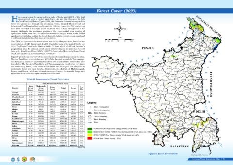
Forest Cover (2023)


                    aryana is primarily an agricultural state of India and 84.28% of the total
                    geographical  area  is  under  agriculture.  As  per  the  Champion  &  Seth
            HClassification of Forest Types (1968), the forests in Haryana belong to three
            forest type groups i.e. Tropical Dry Deciduous Forest, Tropical Thorn Forest and                               N
            Subtropical Pine Forests which are divided into 10 forest types. Over 500 bird species
            have been recorded in the state which is almost 40% of total bird species in the                         W          E
            country.  Although  the  maximum  portion  of  the  geographical  area  consists  of
            agricultural fields, over time, the state has achieved a unique status in the field of
                                                                                                                           S
            agroforestry which has enabled the forest deficient state to support a large number of
            wood-based industries based on farm-grown timber.                                                             Scale
                                                                                                                                       Kms
            The Table 10 represents the forest cover area in the Haryana state, based on the                0  12.5 25   50     75    100
            interpretation of IRS Resourcesat-2 LISS III satellite data of the period Oct to Dec
            2023. The Forest Cover in the State is 398891.72 Acre which is 3.65% of the state’s
            geographical area. In terms of forest canopy density classes, the state has 6713.84
            Acre under Very Dense Forest (VDF), 109017.78 Acre under Moderately Dense Forest
            (MDF) and 283160.09 Acre under Open Forest (OF).
            Figure 9 provides an overview of the distribution of forested areas across the state.
            Notably, Panchkula accounts for over 43% of the forested area while Yamunanagar
            and Faridabad, each have approximately above 10% of the forested area within their
            boundaries. The forests in Panchkula and Yamunanagar are classified as very dense
            and  moderately  dense,  while  those  in  Faridabad  and  Gurugram  are  classified  as
            moderately  dense  and  open  forests.  Additionally,  the  districts  of  Mahendragarh,
            Rewari, and Mewat, which are situated on the outskirts of the Aravalli Range have
            significant areas covered by open forests and shrublands.


                            Table 10 Assessment of Forest Cover Area

                                             2023 Assessment (Area in Acres)
                              Very    Moderately     Open                          % of
             District         Dense     Dense       Forest     Total      Scrub    TGA
                              Forest    Forest
             Ambala            0.00     4277.39     9726.05   14003.44    22.24    3.60
             Bhiwani           0.00     1008.19    14463.06   15471.24   1766.80   1.85
             Charkhi Dadri     0.00      879.69    10467.37   11347.06   2223.95   3.32
             Faridabad         0.00     6419.79    12960.66   19380.45   4991.52   10.58
             Fatehabad         0.00      731.43     4534.38    5265.81    264.40   0.84
             Gurugram          0.00     7870.29    20079.75   27950.05   5045.88   8.99
             Hisar             0.00     2656.38    11809.15   14465.53   1551.82   1.47
             Jhajjar           0.00      56.83      6259.17    6316.00   1588.89   1.39
             Jind              0.00     1183.63     5347.35    6530.99    19.77    0.98
             Kaithal           0.00     5315.23     8107.52   13422.74    234.75   2.34
             Karnal            0.00     1027.96     7114.15    8142.11    165.56   1.32
             Kurukshetra       0.00     4927.27     6446.97   11374.24    417.61   3.00
             Mahendragarh      0.00     5372.06    22133.19   27505.26   9906.44   5.86
             Mewat             0.00     3355.69    23568.87   26924.56   6708.90   7.23
             Palwal            0.00      600.47     2814.53    3414.99    49.42    1.02
             Panchkula       1408.50    36470.23   58521.88   96400.60   5023.64   43.44
             Panipat           0.00      766.03     3180.24    3946.27    158.15   1.24
             Rewari            0.00     2940.55    12244.05   15184.60   2251.13   3.86
             Rohtak            0.00      336.06     3256.84    3592.91    252.05   0.85
             Sirsa             0.00      874.75    15083.29   15958.04    37.07    1.51
             Sonipat           0.00      657.30     4937.16    5594.46    207.57   1.05
             Yamunanagar     5305.34    21290.57   20104.46   46700.37    202.63   10.69
             Haryana         6713.84   109017.78   283160.09   398891.72   43090.17   3.65
                                                                                Source: FSI


                                                                                                                                                         Figure 9. Forest Cover (2023)
                                                                                                                                                                                                     Data Source-FSI, Haryana
                                                                                                                                                                                                     Haryana Water Resources Atlas     13|