
Page 40 - Haryana Water Resources Atlas 2025
P. 40
One-day Maximum Rainfall
N
ne-day maximum rainfall refers to the highest amount of rainfall W E
recorded within a single day in a specific area. This measurement
Ois commonly used to assess the likelihood of flooding and to design
infrastructure like stormwater management systems and drainage S
systems. The one-day maximum rainfall can vary significantly depending Scale
on the location, climate, and season. In regions with high precipitation or Kms
tropical climates, the one-day maximum rainfall can be substantial, 0 12.5 25 50 75 100
sometimes exceeding 100 mm/day or more. In drier areas, the one-day
maximum rainfall may be much lower, often just a few mm. In Haryana,
the one-day maximum rainfall occurs during the monsoon season, which
spans from June to September.
Monitoring the one-day maximum rainfall is crucial to ensure that
infrastructure and emergency response plans are equipped to handle
extreme weather events. It can also help assess the risk of landslides and
other natural disasters as heavy rain can saturate the soil and destabilize
hillsides. The one-day maximum rainfall serves as a critical metric for
understanding the potential impact of intense rainfall in a specific area.
By keeping track of this measurement, communities can better prepare
for severe weather events, mitigate the risk of flooding and address other
natural disaster concerns.
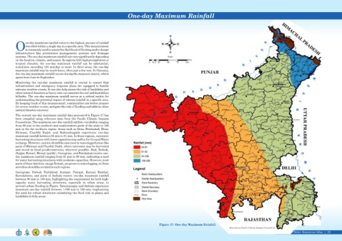
The current one-day maximum rainfall data presented in Figure 17 has
been compiled using reference data from the Pacific Climate Impacts
Consortium. The maximum one-day rainfall exhibits variability, ranging
from 68 mm in the southern and southwestern parts of the state to 126
mm in the far northern region. Areas such as Sirsa, Fatehabad, Hisar,
Bhiwani, Charkhi Dadri, and Mahendragarh experience one-day
maximum rainfall between 68 mm to 81 mm. In these regions, rainwater
harvesting structures with lower capacities may suffice for Ground Water
recharge. However, caution should be exercised in waterlogged areas like
parts of Bhiwani and Charkhi Dadri, where rainwater may be harvested
and stored in lined ponds/reservoirs, wherever possible. Jind, Rohtak,
Jhajjar, Rewari, Mewat (partly), Gurugram, and Fatehabad receive one-
day maximum rainfall ranging from 81 mm to 90 mm, indicating a need
for water harvesting structures with moderate capacities. However, most
parts of these districts, except Rewari, are prone to waterlogging, so these
activities should be avoided in such regions.
Gurugram, Palwal, Faridabad, Sonipat, Panipat, Karnal, Kaithal,
Kurukshetra, and parts of Ambala receive one-day maximum rainfall
between 90 mm to 106 mm, highlighting the requirement for both high-
capacity water harvesting structures, especially in urban areas, to
prevent urban flooding in Figure. Yamunanagar and Ambala experience
maximum one-day rainfall between >106 mm to 126 mm, emphasizing
the need for robust structures considering the flood risk in plains and
landslides in hilly areas.
Figure 17. One day Maximum Rainfall
Data Source-Pacic Climate Impacts Consortium
Haryana Water Resources Atlas 22|