
Page 37 - Haryana Water Resources Atlas 2025
P. 37
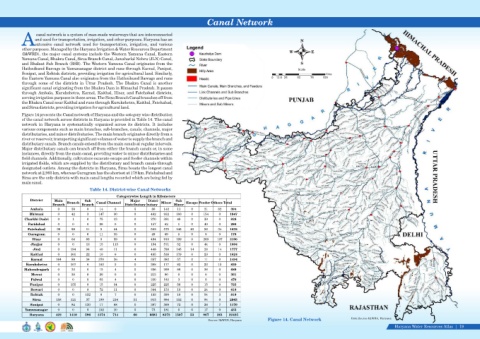
Canal Network


                   canal network is a system of man-made waterways that are interconnected
                  and used for transportation, irrigation, and other purposes. Haryana has an                                                         N
            Aextensive  canal  network  used  for  transportation,  irrigation,  and  various
            other purposes. Managed by the Haryana Irrigation & Water Resources Department
                                                                                                                                                 W         E
            (I&WRD), the major canal systems include the Western Yamuna Canal, Eastern
            Yamuna Canal, Bhakra Canal, Sirsa Branch Canal, Jawaharlal Nehru (JLN) Canal,
            and Bhalaut Sub Branch (BSB). The Western Yamuna Canal originates from the                                                                S
            Hathnikund Barrage in Yamunanagar district and runs through Karnal, Panipat,                                                             Scale
            Sonipat, and Rohtak districts, providing irrigation for agricultural land. Similarly,                                                                  Kms
            the Eastern Yamuna Canal also originates from the Hathnikund Barrage and runs                                               0  12.5 25   50    75    100
            through  some  of  the  districts  in  Uttar  Pradesh.  The  Bhakra  Canal  is  another
            significant canal originating from the Bhakra Dam in Himachal Pradesh. It passes
            through  Ambala,  Kurukshetra,  Karnal,  Kaithal,  Hisar,  and  Fatehabad  districts,
            serving irrigation purposes in these areas. The Sirsa Branch Canal branches off from
            the Bhakra Canal near Kaithal and runs through Kurukshetra, Kaithal, Fatehabad,
            and Sirsa districts, providing irrigation for agricultural land.
            Figure 14 presents the Canal network of Haryana and the category wise distribution
            of the canal network across districts in Haryana is provided in Table 14. The canal
            network  in  Haryana  is  systematically  organized  across  its  districts.  It  includes
            various components such as main branches, sub-branches, canals, channels, major
            distributaries, and minor distributaries. The main branch originates directly from a
            river or reservoir, transporting significant volumes of water to supply the branch and
            distributary canals. Branch canals extend from the main canals at regular intervals.
            Major distributary canals can branch off from either the branch canals or, in some
            instances, directly from the main canal, providing water to minor distributaries and
            field channels. Additionally, cultivators excavate escape and feeder channels within
            irrigated fields, which are supplied by the distributary and branch canals through
            designated outlets. Among the districts in Haryana, Sirsa boasts the longest canal
            network at 2,965 km, whereas Gurugram has the shortest at 178 km. Fatehabad and
            Sirsa are the only districts with main canal lengths recorded which are being fed by
            main canal.
                                             Table 14. District-wise Canal Networks
                                                           Categorywise Length in Kilometers
                District    Main           Sub                    Major    Distri-      Sub
                           Branch   Branch   Branch   Canal Channel   Distributary butary   Minor   Minor   Escape Feeder Others Total
                Ambala        0     39      0     14      0         5       80    142    11     0     21     82     394
                Bhiwani       0     42      3     147    30         0       462   932   180     0     154     0    1947
             Charkhi Dadri    0      1      0     75     13         0       270   381    48     0     39      0     828
               Faridabad      0      0      0     28      0         0       157    62    1      0     40      0     288
               Fatehabad     99     99      11     5     64         0       502   575   145    40     58     34    1632
               Gurugram       0      0      6     11     35         0       49     69    8      0      0      0     178
                 Hisar        0     64      86     3     59         0       494   910   199     0     269    107   2190
                Jhajjar       0      0      13    15     115        0       194   571    52     0     44      0    1004
                 Jind         0     194     94    40     11         0       448   789   145    14     28     14    1777
                Kaithal       0     361     22    10      6         0       485   538   179     0     23      0    1624
                Karnal       164    89      34    370    26         4       357   382    57     0     11      0    1494
              Kurukshetra     0     107     0     103     5         0       308   177    82     0     23     15     820
             Mahendragarh     0     32      0     15      4         0       256   269    86     0     28      0     689
                Mewat         0     30      8     20      0         0       213    90    0      0      0      0     361
                Palwal        0      0      0     62      4         0       220   182    3      0      0      0     470
                Panipat       0     155     0     15     34         0       225   225    56     0     15      0     725
                Rewari        0      0      0     72     11         0       344   153    13     0     24      0     618
                Rohtak        0      0     152     0      7         0       193   390    18     0     54      3     818
                 Sirsa       158    121     37    199    214       51       953   984   152     0     94      0    2965
                Sonipat       0     84     130    17     68         0       397   369    72     0     26      7    1170
             Yamunanagar      0      0      0     152    10         0       73    181    0      0     17      0     433
                Haryana      422   1418    596   1374    714       60      6681   8372   1507   53    967    261   22425
                                                                                                        Source: I&WRD, Haryana        Figure 14. Canal Network                  Data Source-I&WRA, Haryana
                                                                                                                                                                                                     Haryana Water Resources Atlas     19|