
Page 35 - Haryana Water Resources Atlas 2025
P. 35
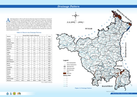
Drainage Pattern


                                                                                                                                    N

                                                                                                                              W          E


                   drainage pattern refers to the layout of streams and rivers that form a network of                               S
                  water channels in a specific geographical region. Numerous elements, including
                                                                                                                                   Scale
            Athe climate, terrain, and geology of the region, affect this pattern. The drainage
                                                                                                                                                Kms
            pattern of Haryana is illustrated in Figure 12, and the lengths corresponding to the                     0  12.5 25   50     75    100
            various stream orders in the area are listed in Table 13. Analysing drainage patterns can
            provide valuable information about the topography and underlying geology of a region.
            Geologists,  hydrologists,  and  environmental  scientists  can  all  benefit  from  this
            information since it makes it easier for them to comprehend and evaluate the numerous
            natural systems at work.

                              Table 13. District-wise Drainage Patterns

                                         Stream Order Length in Kilometer
             District                                                                Total
                               1        2         3         4         5       6
             Ambala          328.6     199.3     102.6     41.8      0.0     0.0     672.3
             Bhiwani         555.2     305.4     248.4     254.0     14.6    0.0    1377.5
             Charkhi Dadri   305.5     151.3     66.4      45.0      48.6    0.0     616.9
             Faridabad       178.4     35.6      27.9       1.1      0.0     45.8    288.7
             Fatehabad       556.1     230.6     133.8     66.1      75.0    0.0    1061.7
             Gurgram         321.1     98.2      45.0      35.0      26.5    0.0     525.8
             Hisar           749.5     368.6     210.7     256.7     66.9    51.5   1703.9
             Jhajjar         448.2     214.8     119.2     52.2      85.6    2.2     922.2
             Jind            539.5     299.0     156.0     165.9     0.0     0.0    1160.4
             Kaithal         460.4     278.8     156.9     83.2      35.5    0.0    1014.7
             Karnal          529.8     312.3     90.6      71.4      51.7    0.0    1055.8
             Kurukshetra     388.4     147.1     94.9      91.1      6.8     0.0     728.2
             Mahendragarh    411.7     203.0     111.5     102.0     0.0     0.0     828.2
             Mewat           313.0     159.2     72.3      71.1      41.5    0.0     657.1
             Palwal          263.1     146.9     30.8      60.7      0.0     31.4    532.9

             Panchkula       174.8     59.8      44.5      26.8      0.0     0.0     306.0
             Panipat         313.3     180.0     63.2       0.0      34.8    0.0     591.3
             Rewari          312.6     202.2     65.8      144.0     0.0     0.0     724.6
             Rohtak          312.6     216.8     76.7      84.7      0.0     0.0     690.7
             Sirsa           755.0     376.0     314.3     194.1    108.1    0.0    1747.6
             Sonipat         415.2     264.8     171.0     24.7      28.2    0.0     903.8
             Yamunanagar     483.4     221.5     60.8      11.5      2.4     0.0     779.7
             Haryana         9115.4   4671.1    2463.3    1883.0    626.2   130.9    18890
                                                                         Source: HARSAC/ GIS Based


                                                                                                                                   Figure 12. Drainage Pattern


                                                                                                                                                                                          Data Source-HARSAC
                                                                                                                                                                                                     Haryana Water Resources Atlas     17|