
Page 135 - Haryana Water Resources Atlas 2025
P. 135
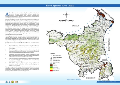
Flood Affected Area (2023)


                                                                                                                                    N
                   flood-affected area is characterized by the inundation of land due to
                  an  overflow  of  water,  typically  caused  by  heavy  rainfall,  river
            Aoverflow,  or  a  combination  of  both.  Figure  91  presented  here                                            W          E
            illustrates the extent of flood-affected regions in Haryana, outlining specific
            areas facing varying degrees of impact.                                                                                 S

            With the highest level of floods, the central and eastern regions of Hisar are                                         Scale
                                                                                                                                                 Kms
            hardest hit. As the floodwaters continue east, they cover large areas of land
                                                                                                                      0  12.5 25   50    75    100
            in Bhiwani's eastern districts. The western parts of Panipat, Sonipat, and
            Karnal  are  also  significantly  affected,  with  the  southern  part  of  Jind
            experiencing substantial flooding. Furthermore, the majority of Rohtak,
            Jhajjar,  and  Mewat  fall  within  the  medium  to  highly-affected  zones,
            amplifying the challenges faced by these areas. In contrast, parts of Sirsa
            and Fatehabad situated along the Ghaggar natural drainage system are
            categorized as low-affected areas. These regions benefit from the drainage
            system's capacity to manage water flow efficiently. Additionally, eastern
            parts of Palwal and Faridabad, aligned with the Yamuna natural drainage
            areas, experience lower levels of flooding, though they are not exempt from
            the challenges posed by waterlogging.
            Waterlogging  compounds  the  issues  in  several  areas,  a  consequence  of
            various  factors  such  as  rainfall  intensity,  soil  conditions,  and  the
            surrounding landscape. The interplay of these elements contributes to the
            vulnerability of Haryana's flood-affected regions, emphasizing the need for
            comprehensive mitigation strategies.
            To address the challenges posed by flooding in Haryana, potential solutions
            include:
            1.     Improved  Drainage  Infrastructure:  Invest  in  robust  drainage
                   systems  and  maintenance  to  enhance  water  flow  and  prevent
                   waterlogging.
            2.     Early Warning Systems: Implement advanced forecasting and early
                   warning systems to provide residents with timely alerts, enabling
                   them to evacuate and minimize loss of life and property.

            3.     Community  Awareness  Programs:  Educate  communities  about
                   flood preparedness, evacuation procedures, and the importance of
                   adhering to local regulations to reduce vulnerability.
            4.     Land Use Planning: Develop and enforce strict land use regulations
                   to  prevent  construction  in  high-risk  flood  zones,  thereby
                   minimizing potential damage.
            5.     Afforestation  Programs:  Increase  green  cover  to  enhance  soil
                   absorption  capacity  and  reduce  surface  runoff,  mitigating  the
                   impact of heavy rainfall.
            Through a comprehensive strategy that integrates technical innovations,
            community  outreach,  infrastructure  development,  and  environmental
            preservation, Haryana may work to strengthen its ability to withstand the
            frequent problems that the region's flooding presents.


                                                                                                                                      Figure 91. Flood Affected Area (2023)
                                                                                                                                                                                                             Data Source-HARSAC
                                                                                                                                                                                                    Haryana Water Resources Atlas     117|