
Page 136 - Haryana Water Resources Atlas 2025
P. 136
Soil Erosion
N
W E
S
oil erosion, the gradual removal of the topsoil layer by Scale
Kms
natural forces such as wind, water, or human 0 12.5 25 50 75 100
Sactivities, is a critical environmental concern that
profoundly impacts land productivity and ecosystem
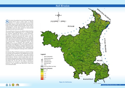
health. Soil Erosion Map of Haryana (Figure 92) provides a
comprehensive visual representation of the erosion
susceptibility across the state, crucial for informed land
management and conservation efforts.
The map delineates Haryana into distinct classes based on
soil erosion values, ranging from 0.1 to > 8 t/ha/year with
six categories capturing the diverse erosion intensities.
Haryana, predominantly characterized by a flat
topography, experiences minimal soil erosion, with the
majority of its expanse falling within the 0.1 to 1 t/ha/year
range. However, two noteworthy regions deviate from this
norm. The northernmost border, encompassing Panchkula
and Yamunanagar exhibits heightened erosion rates
ranging from 1 to > 8 t/ha/year. This anomaly can be
attributed to the sloping terrain of the region, nestled in
the foothills of the Himalayas. The second significant zone
lies along the border of Bhiwani and Hisar, characterized by
desert areas featuring sand dunes. Here, substantial soil
transport occurs, shaping the landscape with considerable
erosion.
Soil Erosion Map of Haryana serves as a crucial resource
for strategic land management. By highlighting areas with
varying degrees of soil erosion, the map enables
policymakers and conservationists to implement targeted
interventions. Precise conservation plans may be
developed by knowing the unique problems that areas like
the northern border and the desert areas around Bhiwani
and Hisar face. In the end, the map is essential to
maintaining soil integrity, encouraging sustainable
practices, and guaranteeing Haryana's long-term
environmental health.
Figure 92. Soil Erosion
Data Source-HARSAC
Haryana Water Resources Atlas 118|