
Page 89 - Haryana Water Resources Atlas 2025
P. 89
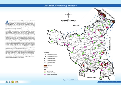
Rainfall Monitoring Stations


                                                                                                                                       N


                                                                                                                                 W          E

                                                                                                                                       S
                                                                                                                                      Scale
                                                                                                                                                   Kms
                   comprehensive overview of three key types of weather
                                                                                                                        0  12.5 25   50     75    100
                  stations  strategically  located  throughout  the  state  is
            Aprovided  by  the  Rainfall  Monitoring  Stations  map  of
            Haryana (Figure 50). These stations are essential for tracking
            and evaluating rainfall patterns, as well as for supplying vital
            information for weather forecasting, agricultural planning, and
            general meteorological evaluations.
            The  map  prominently  features  Agrometeorological  stations
            situated  at  key  locations,  including  Gurgaon,  Karnal,
            Kurukshetra,  Mahendergarh,  Sonipat,  and  Yamunanagar.
            These stations serve as vital nodes for collecting data specifically
            tailored  to  the  agricultural  context,  aiding  farmers  and
            policymakers  in  making  informed  decisions  related  to  crop
            management and water resource utilization. In addition to the
            Agrometeorological stations, the map showcases the extensive
            network  of  Automatic  Rain  Gauge  (ARG)  stations  and
            Automatic Weather Stations (AWS) spread across Haryana. A
            total of 32 ARG stations and 24 AWS stations are strategically
            located to ensure comprehensive coverage of the state. The ARG
            stations  provide  real-time  data  on  precipitation,  enabling
            accurate rainfall monitoring, while the AWS stations contribute
            to broader meteorological observations, including temperature,
            humidity, wind speed, and atmospheric pressure.
            This integrated network of Agrometeorological, ARG, and AWS
            stations reflects Haryana's commitment to harnessing advanced
            technology for precise and timely meteorological data collection.
            The  map  serves  as  a  valuable  resource  for  meteorologists,
            researchers,  and  policymakers,  facilitating  a  deeper
            understanding  of  rainfall  patterns  and  supporting  evidence-
            based decision-making in various sectors.


                                                                                                                                                                                                            Data Source-IMD, India
                                                                                                                             Figure 50. Rainfall Monitoring Stations
                                                                                                                                                                                                     Haryana Water Resources Atlas     71|