
Page 68 - Haryana Water Resources Atlas 2025
P. 68
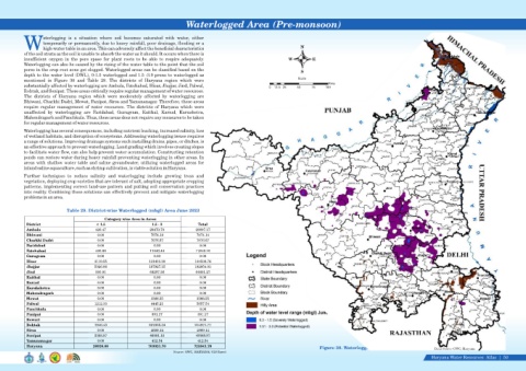
Waterlogged Area (Pre-monsoon)


                    aterlogging  is  a  situation  where  soil  becomes  saturated  with  water,  either
                    temporarily or permanently, due to heavy rainfall, poor drainage, flooding or a
            Whigh-water table in an area. This can adversely affect the beneficial characteristics                                       N
            of the soil strata as the soil is unable to absorb the water as it should. It occurs when there is
            insufficient  oxygen  in  the  pore  space  for  plant  roots  to  be  able  to  respire  adequately.                   W          E
            Waterlogging can also be caused by the rising of the water table to the point that the soil
            pores in the crop root zone get clogged. Waterlogged areas can be classified based on the
                                                                                                                                         S
            depth to the water level (DWL), 0-1.5 waterlogged and 1.5 -3.0 prone to waterlogged as
                                                                                                                                        Scale
            mentioned  in  Figure  30  and  Table  29.  The  districts  of  Haryana  region  which  were
                                                                                                                                                      Kms
            substantially affected by waterlogging are Ambala, Fatehabad, Hisar, Jhajjar, Jind, Palwal,
                                                                                                                           0  12.5 25   50    75    100
            Rohtak, and Sonipat. These areas critically require regular management of water resources.
            The  districts  of  Haryana  region  which  were  moderately  affected  by  waterlogging  are
            Bhiwani, Charkhi Dadri, Mewat, Panipat, Sirsa and Yamunanagar. Therefore, these areas
            require  regular  management  of  water  resources.  The  districts  of  Haryana  which  were
            unaffected  by  waterlogging  are  Faridabad,  Gurugram,  Kaithal,  Karnal,  Kurushetra,
            Mahendragarh and Panchkula. Thus, these areas does not require any measures to be taken
            for regular management of water resources.
            Waterlogging has several consequences, including nutrient leaching, increased salinity, loss
            of wetland habitats, and disruption of ecosystems. Addressing waterlogging issues requires
            a range of solutions. Improving drainage systems such installing drains, pipes, or ditches, is
            an effective approach to prevent waterlogging. Land grading which involves creating slopes
            to facilitate water flow, can also help prevent water accumulation. Constructing retention
            ponds can restore water during heavy rainfall preventing waterlogging in other areas. In
            areas with shallow water table and saline groundwater, utilizing waterlogged areas for
            inland saline aquaculture, such as shrimp cultivation, is viable solution in Haryana.
            Further  techniques  to  reduce  salinity  and  waterlogging  include  growing  tress  and
            vegetation, deploying crop varieties that are tolerant of salt, adopting appropriate cropping
            patterns, implementing correct land-use pattern and putting soil conservation practices
            into reality. Combining these solutions can effectively prevent and mitigate waterlogging
            problems in an area.


                               Table 29. District-wise Waterlogged (mbgl) Area June 2023

                                                Category wise Area in Acres

             District                        < 1.5                    1.5 - 3              Total

             Ambala                         426.47                   20470.70             20897.17

             Bhiwani                         0.00                    7074.14              7074.14

             Charkhi Dadri                   0.00                    7076.67              7076.67
             Faridabad                       0.00                      0.00                0.00

             Fatehabad                      405.66                   17443.44             17849.10
             Gurugram                        0.00                      0.00                0.00
             Hisar                          3119.55                 131411.20            134530.76
             Jhajjar                        5026.86                 187927.15            192954.01

             Jind                           393.91                   64207.36             64601.27

             Kaithal                         0.00                      0.00                0.00

             Karnal                          0.00                      0.00                0.00

             Kurukshetra                     0.00                      0.00                0.00

             Mahendragarh                    0.00                      0.00                0.00
             Mewat                           0.00                    3266.55              3266.55
             Palwal                         1212.33                  4445.21              5657.54
             Panchkula                       0.00                      0.00                0.00

             Panipat                         0.00                     391.17              391.17

             Rewari                          0.00                      0.00                0.00

             Rohtak                         7946.43                 207025.34            214971.77

             Sirsa                           0.00                    4889.14              4889.14

             Sonipat                        2388.87                  46981.10             49369.97
             Yamunanagar                     0.00                     412.54              412.54

             Haryana                       20920.08                 703021.70            723941.78
                                                                                                                                                  Figure 30. Waterlogged Area June 2023               Data Source-GWC, Haryana
                                                                                Source: GWC, HARYANA/ GIS Based
                                                                                                                                                                                                     Haryana Water Resources  Atlas     50|