
Page 60 - Haryana Water Resources Atlas 2025
P. 60
Depth to Water Level (Pre-monsoon)
N
W E
S
Scale
Kms
0 12.5 25 50 75 100
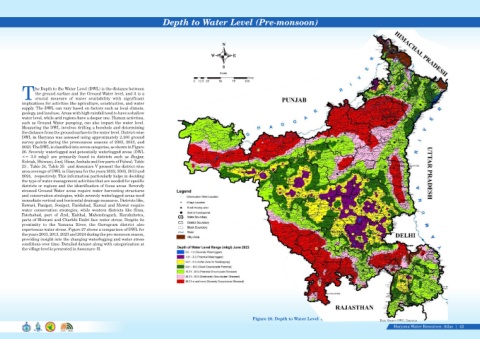
he Depth to the Water Level (DWL) is the distance between
the ground surface and the Ground Water level, and it is a
Tcrucial measure of water availability with significant
implications for activities like agriculture, construction, and water
supply. The DWL can vary based on factors such as local climate,
geology, and land use. Areas with high rainfall tend to have a shallow
water level, while arid regions have a deeper one. Human activities,
such as Ground Water pumping, can also impact the water level.
Measuring the DWL involves drilling a borehole and determining
the distance from the ground surface to the water level. District-wise
DWL in Haryana was assessed using approximately 2,100 ground
survey points during the premonsoon seasons of 2003, 2013, and
2023. The DWL is classified into seven categories, as shown in Figure
26. Severely waterlogged and potentially waterlogged areas (DWL
<= 3.0 mbgl) are primarily found in districts such as Jhajjar,
Rohtak, Bhiwani, Jind, Hisar, Ambala and few parts of Palwal. Table
23 , Table 24, Table 25 and Annexure V present the district-wise
area coverage of DWL in Haryana for the years 2023, 2003, 2013 and
2024, respectively. This information particularly helps in deciding
the type of water management activities that are needed for specific
districts or regions and the identification of focus areas. Severely
stressed Ground Water areas require water harvesting structures
and conservation strategies, while severely waterlogged areas need
immediate vertical and horizontal drainage measures. Districts like,
Rewari, Panipat, Sonipat, Faridabad, Karnal and Mewat require
water conservation strategies, while western districts like Sirsa,
Fatehabad, part of Jind, Kaithal, Mahendragarh, Kurukshetra,
parts of Bhiwani and Charkhi Dadri face water stress. Despite its
proximity to the Yamuna River, the Gurugram district also
experiences water stress. Figure 27 shows a comparison of DWL for
the years 2003, 2013, 2023 and 2024 during the pre-monsoon season,
providing insight into the changing waterlogging and water stress
conditions over time. Detailed dataset along with categorization at
the village level is presented in Annexure- II.
Figure 26. Depth to Water Level June 2023
Data Source-GWC, Haryana
Haryana Water Resources Atlas 42|