
Page 56 - Haryana Water Resources Atlas 2025
P. 56
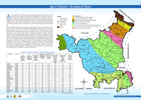
Agro-Climatic / Ecological Zones


                  gro-ecological zones (AEZs) refer to geographic regions characterized by similar
                  environmental conditions that affect their suitability for rain-fed agriculture. At
            Athe regional level, AEZs are influenced by factors such as latitude, elevation,
            temperature, seasonality, and rainfall patterns and amounts during the growing season.
            In Haryana, the agro-climatic/ecological zone has been categorized into eight distinct
            categories by the Soil and Land Use Survey of India, as shown in Figure 22. The table
            presents the area of each agro-ecological zone on a district-wise basis, as detailed in Table
            20.
            The dry subhumid and moderately large water availability zone encompasses the land of
            Ambala, Karnal, Kurukshetra, and Yamunanagar districts. Some areas of Ambala and
            Yamunanagar,  as  well  as  major  portions  of  Panchkula,  fall  within  the  dry  to  moist
            subhumid and moderately large moisture availability category. A section of Sirsa district
            experiences  a  hot  and  dry  climate  with  insignificant  available  moisture.  Bhiwani,
            Charkhi Dadri, Fatehabad, Hisar, Jhajjar, and parts of Rohtak, Sirsa, Mahendragarh,
            Rewari, and Gurugram districts belong to the hot and dry category with little available
            moisture. Jind, Sonipat, Panipat, and Kaithal districts are classified as hot and semi-arid
            with little to moderate water availability, specifically in the Alluvial Plain regions. This
            category also includes certain parts of Karnal, Hisar, Jhajjar, Gurugram, Faridabad,
            Fatehabad,  Palwal,  Rewari,  Mahendragarh,  and  Rohtak  districts.  Mahendragarh,
            Rewari, Mewat, and certain parts of Gurugram fall under the hot and semi-arid category
            with  little  to  moderate  water  availability  in  hilly  terrain.     Karnal,  a  portion  of

            Kurukshetra, Faridabad, Kaithal, and Palwal districts are classified as hot and semi-arid


            with moderate water availability, as depicted in Figure 22.


                                     Table 20. District-wise Agro - Climate/Ecological Zones

                District   TGA                                     Category wise Area in '000 Acres
                                      Dry        Dry     Dry to moist   Hot and dry     Hot and   Hot and semi-  Hot and semi-  Hot and

                                    subhumid   subhumid   subhumid   insignificant   dry little   arid little to   arid little to   semi-arid

                                   moderately     moderately   moderately   available   available   moderate   moderate   moderate

                                     large    large water   large     moisture  moisture    water        water       water

                                    moisture   availability  moisture                      available    available   availability
                                   availability          availability                      moisture      moisture
                                                                                            (Alluvial   (Hilly Terain)

                                                                                             Plain)
             Ambala        388.94    99.27      254.63      27.89      0.00       0.00       0.00         0.00        7.16

             Bhiwani       848.06     0.00       0.00       0.00       0.00      833.94      0.00        14.13        0.00

             Charkhi Dadri  332.60    0.00       0.00       0.00       0.00      315.38      0.00        17.22        0.00

             Faridabad     183.10     0.00       0.00       0.00       0.00       0.00      56.19         0.00       126.91

             Fatehabad     627.15     0.00       0.00       0.00       0.00      526.72     100.43        0.00        0.00

             Gurugram      310.86     0.00       0.00       0.00       0.00      18.91      154.59       137.36       0.00
             Hisar         984.22     0.00       0.00       0.00       0.00       817.26      166.95      0.00         0.00

             Jhajjar       453.19     0.00       0.00       0.00       0.00       336.49     110.65       6.05         0.00
             Jind          667.68     0.00       0.00       0.00       0.00       0.00       667.68       0.00         0.00
             Kaithal       572.54     0.00       0.00       0.00       0.00       0.00       479.00       0.00         93.54
             Karnal        622.70     0.00       78.36      0.00       0.00       0.00       191.75       0.00         352.59
             Kurukshetra     378.07     0.00     229.48     0.00       0.00       0.00        3.00        0.00       145.60

             Mahendragarh  469.25     0.00       0.00       0.00       0.00       17.17      0.00         452.08        0.00                  N

             Mewat         372.39     0.00       0.00       0.00       0.00       0.00      19.38        353.01       0.00

             Palwal        335.82     0.00       0.00       0.00       0.00       0.00      241.94       36.45       57.42
                                                                                                                                        W          E
             Panchkula     221.90    15.05       0.00      206.85      0.00       0.00       0.00         0.00        0.00

             Panipat       313.33     0.00       0.00       0.00       0.00       0.00      295.94        0.00       17.39

             Rewari        393.89     0.00       0.00       0.00       0.00      41.79       0.00        352.09       0.00                    S

             Rohtak        431.20     0.00       0.00       0.00       0.00      163.42     267.78        0.00        0.00                   Scale
             Sirsa        1056.87     0.00       0.00       0.00       383.05      673.82     0.00        0.00         0.00                                Kms
             Sonipat       524.36     0.00       0.00       0.00       0.00       0.00       524.36       0.00         0.00     0    12.5 25   50   75   100
             Yamunanagar    436.88     173.12     153.80     109.96     0.00      0.00       0.00         0.00        0.00
             Haryana      10925.01     287.44     716.27     345.72     383.05   3744.91      3279.63    1367.37        800.62
                                                                                                         Source: SLUSI, INDIA/ GIS Based
                                                                                                                                               Figure 22. Agro-Climatic / Ecological Zones             Data Source-SLUSI, India
                                                                                                                                                                                                     Haryana Water Resources  Atlas     38|