
Page 64 - Haryana Water Resources Atlas 2025
P. 64
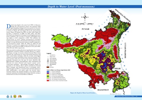
Depth to Water Level (Post-monsoon)


                                                                                                                                               N


                                                                                                                                         W          E

                                                                                                                                               S
                                                                                                                                             Scale
                                                                                                                                                           Kms
                   istrict-wise depth to the water level (DWL) in Haryana                                                       0  12.5 25   50     75    100
                   during  the  post-monsoon  season  was  assessed  using
            Dapproximately 2,100 ground survey points for the years
            2003, 2013, and 2023. The DWL is categorized into seven classes,
            as  shown  in  Figure  28  and  Figure  29  for  the  post-monsoon
            season. Figure 28 displays the DWL for 2023, while Figure 29
            provides  a  comparison  of  DWL  for  2003,  2013,  and  2023,
            allowing for an assessment of changes in waterlogging and water
            stress conditions. The coverage of severely waterlogged areas
            was  higher  in  2013  compared  to  2023.  This  indicates  the
            effectiveness  of  water  logging  management  strategies
            implemented in Haryana. The potential waterlogged areas have
            a larger coverage during the post-monsoon season compared to
            the  pre-monsoon  season.  Table  26,  Table  27,  Table  28  and
            Annexure  V  present  the  category-wise  and  district-wise  area
            coverage of post-monsoon DWL in Haryana for the years 2023,
            2003, 2013 and  2024, respectively.
            This map assists in making decisions regarding the type of water
            management activities needed in specific districts or regions.
            The larger coverage of severely stressed Ground Water areas
            indicates the requirement for water harvesting structures and
            water conservation strategies, while the severely waterlogged
            category necessitates immediate water removal strategies. The
            area coverage under the severely water-stressed category has
            gradually  increased  over  the  past  20  years.  Districts  like
            Mahendragarh, Kaithal, Kurukshethra, Sirsa, Fatehabad and
            Bhiwani  are  most  affected  and  require  urgent  water
            conservation strategies.   Interestingly, Gurugram, despite its
            proximity to the Yamuna River and its potential for Ground
            Water  recharge,  has  transitioned  from  a  potentially  water-
            stressed region in 2003 to a severely water-stressed category in

            2023.  Additionally,  a  new  patch  under  the  severely  water-

            stressed category has emerged parallel to the Yamuna River,

            primarily spanning the Panipat and Sonipat districts, posing a

            serious issue in terms of Ground Water conditions.


                                                                                                                       Figure 28. Depth to Water Level October 2023
                                                                                                                                                                                          Data Source-GWC, Haryana
                                                                                                                                                                                                     Haryana Water Resources  Atlas     46|