
Page 36 - Haryana Water Resources Atlas 2025
P. 36
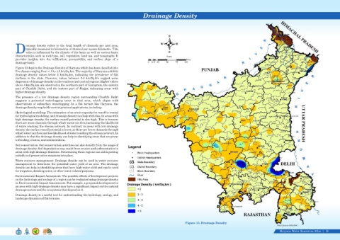
Drainage Density


                                                                                                                       N


                                                                                                                  W         E
                   rainage  density  refers  to  the  total  length  of  channels  per  unit  area,
                   typically measured in kilometres of channel per square kilometre. This
            Dvalue is influenced by the climate of the basin as well as various basin                                  S
            characteristics such as rock type, soil, vegetation, land use, and topography. It                         Scale
            provides  insights  into  the  infiltration,  permeability,  and  surface  slope  of  a                                 Kms
            drainage basin.                                                                              0  12.5 25   50    75    100
            Figure 13 depicts the Drainage Density of Haryana which has been classified into
            five classes ranging from < 2 to ≥5 km/Sq.km. The majority of Haryana exhibits
            drainage  density  values  below  2  km/Sq.km,  indicating  the  prevalence  of  flat
            surfaces  in  the  state.  However,  values  between  2-3  km/Sq.km  suggest  some
            dispersion of drainage density in the southern and central regions. Higher values
            above 4 km/Sq.km are observed in the northern part of Gurugram, the eastern
            part of Charkhi Dadri, and the eastern part of Jhajjar, indicating areas with
            higher drainage density.
            The  presence  of  a  low  drainage  density  region  surrounding  Charkhi  Dadri
            suggests  a  potential  waterlogging  issue  in  that  area,  which  aligns  with
            observations  of  subsurface  waterlogging.  In  a  flat  terrain  like  Haryana,  the
            drainage density map holds various practical applications, including:

            Hydrological modelling: The estimation of an area's capacity for runoff is crucial
            for hydrological modelling, and drainage density can help with this. In areas with
            high drainage density, the surface runoff potential is also high. This is because
            there are more channels through which water can flow, increasing the likelihood
            of water reaching the stream network. In contrast, in areas with low drainage
            density, the surface runoff potential is lower, as there are fewer channels through
            which water can flow and less likelihood of water reaching the stream network. In
            addition to that the drainage density can help in identifying areas that are prone
            to flooding, erosion, and sedimentation.
            Soil conservation: Soil conservation activities can also benefit from the usage of
            drainage density. Soil degradation may result from erosion and sedimentation in
            areas with high drainage densities. Determining these regions can aid in putting
            suitable soil preservation measures into place.
            Water resource management: Drainage density can be used in water resource
            management to determine the potential water yield of an area. The drainage
            density can help in identifying areas that have high water yield and can be used
            for irrigation, drinking water, or other water-related purposes.

            Environmental Impact Assessment: The possible effects of development projects
            on the hydrology and ecology of a region can be evaluated using drainage density
            in Environmental Impact Assessments. For example, a proposed development in
            an area with high drainage density may have a significant impact on the natural
            drainage system and the ecosystems that depend on it.
            Drainage density is a useful tool for understanding the hydrology, ecology, and
            landscape dynamics of flat terrains.


                                                                                                                                   Figure 13. Drainage Density
                                                                                                                                                                                                    Data Source-HARSAC

                                                                                                                                                                                                     Haryana Water Resources Atlas     18|