
Page 20 - Haryana Water Resources Atlas 2025
P. 20
Administrative Divisions and Climate
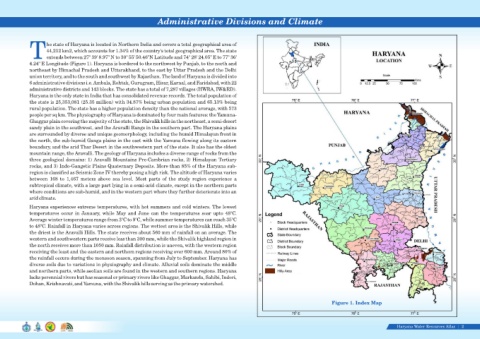
he state of Haryana is located in Northern India and covers a total geographical area of
44,212 km2, which accounts for 1.34% of the country's total geographical area. The state
Textends between 27° 39' 8.97" N to 30° 55' 50.46"N Latitude and 74° 28' 24.05" E to 77° 36'
4.24" E Longitude (Figure 1). Haryana is bordered to the northwest by Punjab, to the north and
northeast by Himachal Pradesh and Uttarakhand, to the east by Uttar Pradesh and the Delhi
union territory, and to the south and southwest by Rajasthan. The land of Haryana is divided into
6 administrative divisions i.e. Ambala, Rohtak, Gurugram, Hisar, Karnal, and Faridabad, with 22
administrative districts and 143 blocks. The state has a total of 7,287 villages (HWRA, IW&RD).
Haryana is the only state in India that has consolidated revenue records. The total population of
the state is 25,353,081 (25.35 million) with 34.87% being urban population and 65.13% being
rural population. The state has a higher population density than the national average, with 573
people per sq km. The physiography of Haryana is dominated by four main features: the Yamuna-
Ghaggar plain covering the majority of the state, the Shivalik hills in the northeast, a semi-desert
sandy plain in the southwest, and the Aravalli Range in the southern part. The Haryana plains
are surrounded by diverse and unique geomorphology, including the humid Himalayan front in
the north, the sub-humid Ganga plains in the east with the Yamuna flowing along its eastern
boundary, and the arid Thar Desert in the southwestern part of the state. It also has the oldest
mountain range, the Aravalli. The geology of Haryana includes a diverse range of rocks from the
three geological domains: 1) Aravalli Mountains Pre-Cambrian rocks, 2) Himalayan Tertiary
rocks, and 3) Indo-Gangetic Plains Quaternary Deposits. More than 85% of the Haryana sub-
region is classified as Seismic Zone IV thereby posing a high risk. The altitude of Haryana varies
between 168 to 1,467 meters above sea level. Most parts of the study region experience a
subtropical climate, with a large part lying in a semi-arid climate, except in the northern parts
where conditions are sub-humid, and in the western part where they further deteriorate into an
arid climate.
Haryana experiences extreme temperatures, with hot summers and cold winters. The lowest
temperatures occur in January, while May and June can the temperatures soar upto 48°C.
Average winter temperatures range from 3°C to 9°C, while summer temperatures can reach 35°C
to 48°C. Rainfall in Haryana varies across regions. The wettest area is the Shivalik Hills, while
the driest is the Aravalli Hills. The state receives about 560 mm of rainfall on an average. The
western and southwestern parts receive less than 300 mm, while the Shivalik highland region in
the north receives more than 1050 mm. Rainfall distribution is uneven, with the western region
receiving the least and the eastern and northern regions receiving over 600 mm. Around 80% of
the rainfall occurs during the monsoon season, spanning from July to September. Haryana has
diverse soils due to variations in physiography and climate. Alluvial soils dominate the middle
and northern parts, while aeolian soils are found in the western and southern regions. Haryana
lacks perennial rivers but has seasonal or primary rivers like Ghaggar, Markanda, Sahibi, Indori,
Dohan, Krishnavati, and Yamuna, with the Shivalik hills serving as the primary watershed.
Figure 1. Index Map
Haryana Water Resources Atlas 2|